
Make a donation
Gear up for your next adventure:
As an Amazon Associate, this site earns from qualifying purchases at no extra cost to you.
Himmelpfort topographic map
Click on the map to display elevation.
Make a donation
Gear up for your next adventure:
As an Amazon Associate, this site earns from qualifying purchases at no extra cost to you.
About this map
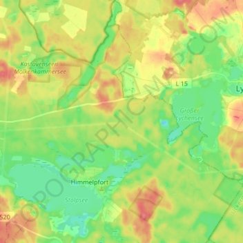
Name: Himmelpfort topographic map, elevation, terrain.
Average elevation: 217 ft
Minimum elevation: 131 ft
Maximum elevation: 318 ft
Make a donation
Gear up for your next adventure:
As an Amazon Associate, this site earns from qualifying purchases at no extra cost to you.
Other topographic maps
Click on a map to view its topography, its elevation and its terrain.
Großmenow
Deutschland > Brandenburg > Oberhavel > Fürstenberg/Havel > Großmenow
Average elevation: 226 ft
Steinhavelmühle
Deutschland > Brandenburg > Oberhavel > Fürstenberg/Havel > Steinförde
Average elevation: 210 ft
Make a donation
Gear up for your next adventure:
As an Amazon Associate, this site earns from qualifying purchases at no extra cost to you.