
Make a donation
Gear up for your next adventure:
As an Amazon Associate, this site earns from qualifying purchases at no extra cost to you.
Klasdorf topographic map
Click on the map to display elevation.
Make a donation
Gear up for your next adventure:
As an Amazon Associate, this site earns from qualifying purchases at no extra cost to you.
About this map
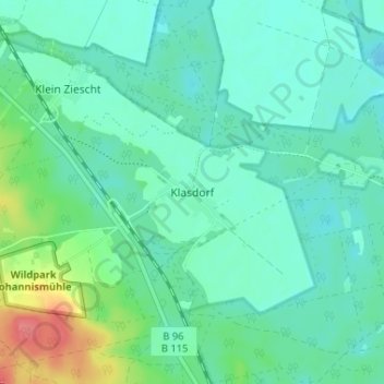
Name: Klasdorf topographic map, elevation, terrain.
Average elevation: 207 ft
Minimum elevation: 154 ft
Maximum elevation: 374 ft
Make a donation
Gear up for your next adventure:
As an Amazon Associate, this site earns from qualifying purchases at no extra cost to you.
Other topographic maps
Click on a map to view its topography, its elevation and its terrain.
Groß Ziescht
Deutschland > Brandenburg > Teltow-Fläming > Baruth/Mark
1474 ergaben sich aus dem Verzeichnis Der Mannschaft des Landes Sachsen Einkommen detaillierte Einblicke in die Einwohnerstruktur. Ein Anteil des Dorfes besaßen Offe und Jorge von Schlieben. Sie erhielten vom Richter 12 Groschen (gr) für ein Lehnpferd. Ein Einwohner zahlte 14 gr 7 Pfennig (d), der Lehnmann…
Average elevation: 423 ft
Petkus
Deutschland > Brandenburg > Teltow-Fläming > Baruth/Mark
Der Ort gehörte bis 1815 – als damals nördlichster Ort im Amt Schlieben – zum Königreich Sachsen und kam mit dem Wiener Kongress und der Auflösung der Exklaven zu Preußen. Im Dorf arbeiteten mittlerweile zahlreiche Gewerke: Es gab einen Schuhmachermeister, einen Rad- und Stellmachermeister, einen…
Average elevation: 417 ft
Make a donation
Gear up for your next adventure:
As an Amazon Associate, this site earns from qualifying purchases at no extra cost to you.