
Make a donation
Gear up for your next adventure:
As an Amazon Associate, this site earns from qualifying purchases at no extra cost to you.
Rente de Valmy topographic map
Click on the map to display elevation.
Make a donation
Gear up for your next adventure:
As an Amazon Associate, this site earns from qualifying purchases at no extra cost to you.
About this map
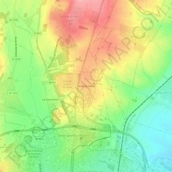
Name: Rente de Valmy topographic map, elevation, terrain.
Average elevation: 922 ft
Minimum elevation: 741 ft
Maximum elevation: 1,119 ft
Make a donation
Gear up for your next adventure:
As an Amazon Associate, this site earns from qualifying purchases at no extra cost to you.
Other topographic maps
Click on a map to view its topography, its elevation and its terrain.
Dijon (canton de Dijon-6)
France > Bourgogne-Franche-Comté > Côte-d'Or > Dijon
Average elevation: 1,007 ft
Make a donation
Gear up for your next adventure:
As an Amazon Associate, this site earns from qualifying purchases at no extra cost to you.
Parc de la Combe à la Serpent
France > Bourgogne-Franche-Comté > Côte-d'Or > Dijon
Average elevation: 1,227 ft
Palais des Ducs et États de Bourgogne
France > Bourgogne-Franche-Comté > Côte-d'Or > Dijon
Average elevation: 817 ft