Geolocate

Custer topographic map

Click on the map to display elevation.

Custer

Winter weather is dominated by the conflict between cold Arctic air moving south from Canada, and very warm chinook winds which can produce exceptionally high winter temperatures for the latitude and altitude. For instance, January 19 of 1963 saw the coldest temperature ever of −43 °F (−41.7 °C), yet in just over two weeks on February 5, Custer reached 65 °F (18.3 °C).

Wikipedia (CC-BY-SA 3.0)

About this map

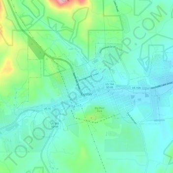
Name: Custer topographic map, elevation, terrain.

Location: Custer, Custer County, South Dakota, 57730, United States (43.75623 -103.62283 43.78059 -103.56572)

Average elevation: 5,446 ft

Minimum elevation: 5,259 ft

Maximum elevation: 6,063 ft

Custer County trails, hiking, mountain biking, running and outdoor activities

Other topographic maps

Click on a map to view its topography, its elevation and its terrain.

Needles Eye

United States > South Dakota > Custer County

Average elevation: 6,247 ft

Stockade Lake

United States > South Dakota > Custer County

Average elevation: 5,302 ft

Blue Bell

United States > South Dakota > Custer County

Average elevation: 5,046 ft

Fourmile

United States > South Dakota > Custer County

Average elevation: 5,476 ft

Gear up for your next adventure:

🪑Ultralight Camp Chairs - Portable seating for resting after a long day of mapping
🩳Quick‑Dry Hiking Shorts - Comfortable and quick‑dry shorts for summer hiking
😴Insulated Sleeping Pads - Compact and warm pads for high-elevation camping
🔭Telescopic Hiking Pole - Adjustable pole for hiking stability
👖Convertible Hiking Pants - Versatile zip-off pants for changing altitudes and temperatures

As an Amazon Associate, this site earns from qualifying purchases at no extra cost to you.