Geolocate

Kingston topographic map

Click on the map to display elevation.

About this map

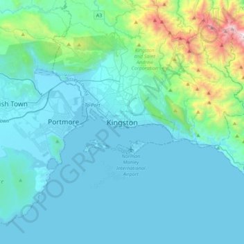
Name: Kingston topographic map, elevation, terrain.

Location: Kingston, Kingston and Saint Andrew Corporation, Surrey County, Jamaica (17.81121 -76.95281 18.13121 -76.63281)

Average elevation: 810 ft

Minimum elevation: -10 ft

Maximum elevation: 6,719 ft

Other topographic maps

Click on a map to view its topography, its elevation and its terrain.

Hope River

Jamaica > Kingston > Kingston

Average elevation: 1,257 ft

Gear up for your next adventure:

🔪Outdoor Multitools - Essential survival tools for gear repair and field use
🏫Relief Map Kits - Hands-on tools for teaching landforms and elevation
🛰️Handheld GPS Units - Professional satellite navigators for precise backcountry mapping
🌧️Backpack Rain Cover - Keep gear dry in wet weather
🪶Trail Camera - Capture wildlife on your hikes

As an Amazon Associate, this site earns from qualifying purchases at no extra cost to you.