
Make a donation
Gear up for your next adventure:
As an Amazon Associate, this site earns from qualifying purchases at no extra cost to you.
San Gabriele topographic map
Click on the map to display elevation.
Make a donation
Gear up for your next adventure:
As an Amazon Associate, this site earns from qualifying purchases at no extra cost to you.
About this map
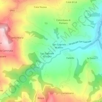
Name: San Gabriele topographic map, elevation, terrain.
Location: San Gabriele, Piozzano, Piacenza, Emilia-Romagna, Italia (44.90737 9.46598 44.91151 9.47377)
Average elevation: 1,257 ft
Minimum elevation: 781 ft
Maximum elevation: 1,903 ft
Make a donation
Gear up for your next adventure:
As an Amazon Associate, this site earns from qualifying purchases at no extra cost to you.
Other topographic maps
Click on a map to view its topography, its elevation and its terrain.
Castello di Monteventano
Italia > Emilia-Romagna > Piacenza > Piozzano > Castello di Monteventano
Average elevation: 1,322 ft
Make a donation
Gear up for your next adventure:
As an Amazon Associate, this site earns from qualifying purchases at no extra cost to you.