Geolocate

Hildesheim topographic map

Click on the map to display elevation.

About this map
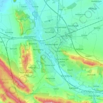
Name: Hildesheim topographic map, elevation, terrain.

Location: Hildesheim, Landkreis Hildesheim, Lower Saxony, Germany (52.09358 9.84655 52.19391 10.04285)

Average elevation: 394 ft

Minimum elevation: 217 ft

Maximum elevation: 978 ft

Other topographic maps

Click on a map to view its topography, its elevation and its terrain.

Söhre

Germany > Lower Saxony > Landkreis Hildesheim

Average elevation: 456 ft

Barienrode

Germany > Lower Saxony > Landkreis Hildesheim

Average elevation: 364 ft

Ahstedt

Germany > Lower Saxony > Landkreis Hildesheim > Schellerten

Average elevation: 279 ft

Mehle

Germany > Lower Saxony > Landkreis Hildesheim > Elze

Average elevation: 358 ft

Gear up for your next adventure:

🌐World Map Poster - Decorative world maps with topographic info
🦟Ultrasonic Repellers - Create a bug-free zone at your camp or rest stop
📻Weather Alert Radios - Stay informed of storm risks while off-the-grid
🗺️NatGeo Topo Maps - High-quality waterproof printed topographic maps of US Parks
🧯Portable Fire Pit - Compact fire pit for camping spots

As an Amazon Associate, this site earns from qualifying purchases at no extra cost to you.