Geolocate

Mehle topographic map

Click on the map to display elevation.

About this map

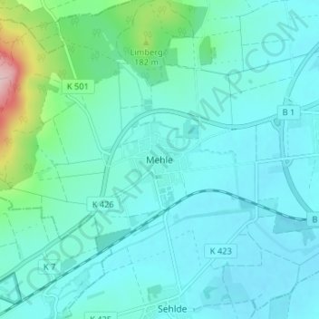
Name: Mehle topographic map, elevation, terrain.

Location: Mehle, Elze, Landkreis Hildesheim, Lower Saxony, 31008, Germany (52.09595 9.67581 52.13595 9.71581)

Average elevation: 358 ft

Minimum elevation: 246 ft

Maximum elevation: 994 ft

Other topographic maps

Click on a map to view its topography, its elevation and its terrain.

31008

Germany > Lower Saxony > Landkreis Hildesheim > Elze > Mehle

Average elevation: 322 ft

Gear up for your next adventure:

🧼Biodegradable Camping Soap - Eco‑friendly soap for outdoor hygiene
🪶Wildlife Field Guides - Learn animal tracking and species ID
🥇GPS Hiking Watch - Multi‑sport GPS watch with navigation and trail tracking
🚁Photography Drones - Capture stunning aerial views of landforms and topography
🔪Outdoor Multitools - Essential survival tools for gear repair and field use

As an Amazon Associate, this site earns from qualifying purchases at no extra cost to you.