Geolocate

Hector topographic map

Click on the map to display elevation.

About this map

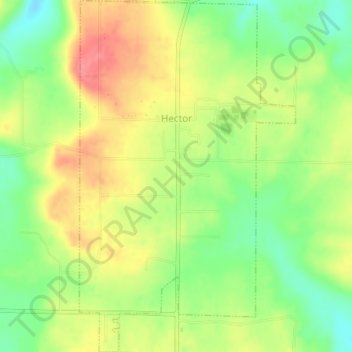
Name: Hector topographic map, elevation, terrain.

Location: Hector, Pope County, Arkansas, 72843, United States (35.44665 -92.98607 35.47921 -92.96148)

Average elevation: 722 ft

Minimum elevation: 600 ft

Maximum elevation: 846 ft

Pope County trails, hiking, mountain biking, running and outdoor activities

Other topographic maps

Click on a map to view its topography, its elevation and its terrain.

Rock Springs

United States > Arkansas > Pope County

Average elevation: 715 ft

Moreland

United States > Arkansas > Pope County

Average elevation: 774 ft

Smyrna

United States > Arkansas > Pope County

Average elevation: 1,319 ft

Dover

United States > Arkansas > Pope County > Dover > Dover

The mild hills historically supported oak-hickory forest or oak-hickory-pine forest. Elevation changes and soil types make the Arkansas Valley Hills largely unsuitable for row agriculture. Instead, forest has been cleared for pastureland, poultry farming or ranching. Logging remains an important land use where…

Average elevation: 492 ft

Moreland

United States > Arkansas > Pope County > Moreland

Average elevation: 774 ft

Gear up for your next adventure:

🪶Multi‑Purpose Knife - Useful blade for camp and trail
🛠️Backpacking Tool Kit - Essential toolkit for outdoor repairs
🥾Women's Hiking Boots - Top-rated trail boots with ankle support and superior grip
😴Insulated Sleeping Pads - Compact and warm pads for high-elevation camping
🔭Compact Binoculars - HD vision for scouting terrain and identifying distant landmarks

As an Amazon Associate, this site earns from qualifying purchases at no extra cost to you.