
Make a donation
Gear up for your next adventure:
As an Amazon Associate, this site earns from qualifying purchases at no extra cost to you.
Schöppinger Berg topographic map
Click on the map to display elevation.
Make a donation
Gear up for your next adventure:
As an Amazon Associate, this site earns from qualifying purchases at no extra cost to you.
Schöppinger Berg
Der Schöppinger Berg ist eine maximal 157,6 m ü. NN hohe Erhebung, je etwa 2,5 km östlich von Schöppingen (Kreis Borken) und nordwestlich von Horstmar (Kreis Steinfurt). Er stellt den Höhenschwerpunkt des Schöppinger Rückens dar, der von den Baumbergen nach Norden abzweigt.
Make a donation
Gear up for your next adventure:
As an Amazon Associate, this site earns from qualifying purchases at no extra cost to you.
About this map
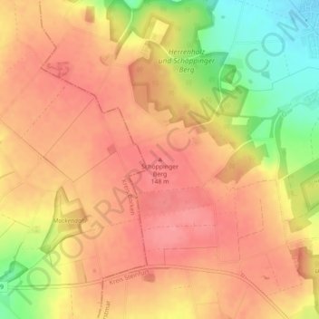
Name: Schöppinger Berg topographic map, elevation, terrain.
Average elevation: 433 ft
Minimum elevation: 249 ft
Maximum elevation: 525 ft
Make a donation
Gear up for your next adventure:
As an Amazon Associate, this site earns from qualifying purchases at no extra cost to you.