Geolocate

Silchar topographic map

Click on the map to display elevation.

About this map

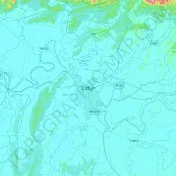
Name: Silchar topographic map, elevation, terrain.

Location: Silchar, Cachar, Assam, 788014, India (24.66959 92.63715 24.98959 92.95715)

Average elevation: 105 ft

Minimum elevation: 30 ft

Maximum elevation: 1,772 ft

Gear up for your next adventure:

🎁Geography Themed Gifts - Unique gift ideas for map lovers and geography enthusiasts
🛰️Satellite Messengers - Emergency SOS and two-way messaging for off-grid adventures
🌧️Backpack Rain Cover - Keep gear dry in wet weather
💧Water Filtration Bottles - Safely drink from streams and lakes while exploring
🧼Biodegradable Camping Soap - Eco‑friendly soap for outdoor hygiene

As an Amazon Associate, this site earns from qualifying purchases at no extra cost to you.