
Andrimont topographic map
Interactive map
Click on the map to display elevation.
About this map
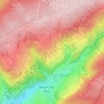
Name: Andrimont topographic map, elevation, terrain.
Location: Andrimont, Stoumont, Verviers, Liège, Wallonie, 4821, Belgique (50.41868 5.87019 50.45868 5.91019)
Average elevation: 1,470 ft
Minimum elevation: 787 ft
Maximum elevation: 1,903 ft
Other topographic maps
Click on a map to view its topography, its elevation and its terrain.
Borgoumont
Belgique > Liège > Verviers > Stoumont
Borgoumont, Stoumont, Verviers, Liège, Wallonie, 4987, Belgique
Average elevation: 1,306 ft
Xhierfomont
Belgique > Liège > Verviers > Stoumont
Xhierfomont, Stoumont, Verviers, Liège, Wallonie, 4987, Belgique
Average elevation: 968 ft
Château de Froidcourt
Belgique > Liège > Verviers > Stoumont
Château de Froidcourt, 8, Froidcour, Stoumont, Verviers, Liège, Wallonie, 4987, Belgique
Average elevation: 1,040 ft
Grimbiémont
Belgique > Liège > Verviers > Stoumont
Grimbiémont, Stoumont, Verviers, Liège, Wallonie, 4987, Belgique
Average elevation: 1,132 ft