
Thank you for supporting this site ❤️
Make a donation
Make a donation
Gear up for your next adventure:
As an Amazon Associate, this site earns from qualifying purchases at no extra cost to you.
São Luiz do Purunã topographic map
Click on the map to display elevation.
Thank you for supporting this site ❤️
Make a donation
Make a donation
Gear up for your next adventure:
As an Amazon Associate, this site earns from qualifying purchases at no extra cost to you.
About this map
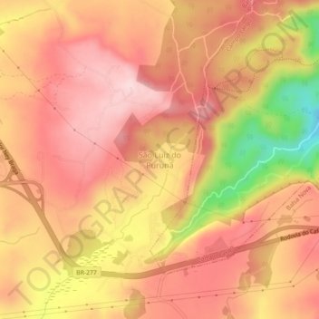
Name: São Luiz do Purunã topographic map, elevation, terrain.
Average elevation: 3,455 ft
Minimum elevation: 2,822 ft
Maximum elevation: 3,760 ft
Thank you for supporting this site ❤️
Make a donation
Make a donation
Gear up for your next adventure:
As an Amazon Associate, this site earns from qualifying purchases at no extra cost to you.
Other topographic maps
Click on a map to view its topography, its elevation and its terrain.
Rio Itaqui
Brasil > Paraná > Região Metropolitana de Curitiba > Balsa Nova
Average elevation: 3,054 ft