
Make a donation
Gear up for your next adventure:
As an Amazon Associate, this site earns from qualifying purchases at no extra cost to you.
Medel (Lucmagn) topographic map
Click on the map to display elevation.
Make a donation
Gear up for your next adventure:
As an Amazon Associate, this site earns from qualifying purchases at no extra cost to you.
Medel (Lucmagn)
Before 2017, the municipality was located in the Disentis sub-district of the Surselva district, after 2017 it was part of the Surselva Region. It is located in the Medelserrhein river basin. It includes the 16 km (9.9 mi) long Medel Valley, which connects Upper Graubünden with the canton of Ticino. It consists of a number of settlements at an elevation of 1,332–1,621 meters (4,370–5,318 ft). These include: Curaglia (main village), Soliva, Mutschnengia, Platta, Drual/Matergia, Pardé, Fuorns and S. Gions. The municipality also includes about 50 abandoned farm houses and summer herding camps, including Pali, Biscuolm and Casura. Until 1943 Medel (Lucmagn) was known as Medels im Oberland.
Make a donation
Gear up for your next adventure:
As an Amazon Associate, this site earns from qualifying purchases at no extra cost to you.
About this map
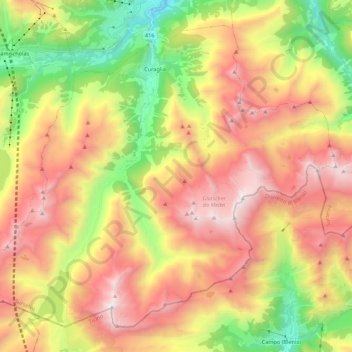
Name: Medel (Lucmagn) topographic map, elevation, terrain.
Location: Medel (Lucmagn), Surselva, Grisons, Switzerland (46.56313 8.75041 46.69194 8.96910)
Average elevation: 6,890 ft
Minimum elevation: 3,415 ft
Maximum elevation: 10,430 ft
Make a donation
Gear up for your next adventure:
As an Amazon Associate, this site earns from qualifying purchases at no extra cost to you.
Other topographic maps
Click on a map to view its topography, its elevation and its terrain.
Make a donation
Gear up for your next adventure:
As an Amazon Associate, this site earns from qualifying purchases at no extra cost to you.