Geolocate

Matti topographic map

Click on the map to display elevation.

About this map

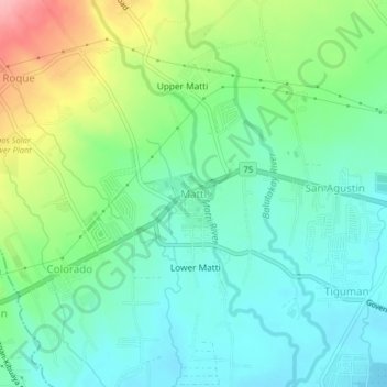
Name: Matti topographic map, elevation, terrain.

Location: Matti, Digos, Davao del Sur, Davao Region, 8002, Philippines (6.74778 125.28620 6.78778 125.32620)

Average elevation: 171 ft

Minimum elevation: 43 ft

Maximum elevation: 463 ft

Gear up for your next adventure:

🛠️Backpacking Tool Kit - Essential toolkit for outdoor repairs
🕶️GPS Smartphone Mount - Secure mount for phone navigation
🪶Camping Sleeping Pad - Comfortable sleeping pad for backpacking
🚑Emergency Bivvies - Heat-reflective sleeping bags for survival situations
🌡️Portable Weather Meter - Track weather conditions on the trail

As an Amazon Associate, this site earns from qualifying purchases at no extra cost to you.