Geolocate

Bicholim topographic map

Click on the map to display elevation.

Bicholim

Bicholim is located at 15°36′N 73°57′E / 15.60°N 73.95°E / 15.60; 73.95. It has an average elevation of 22 metres (72 feet).

Wikipedia (CC-BY-SA 3.0)

About this map

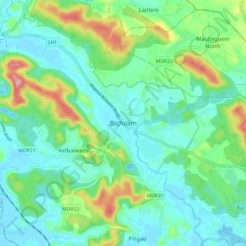
Name: Bicholim topographic map, elevation, terrain.

Location: Bicholim, North Goa, Goa, 403504, India (15.55090 73.90651 15.63090 73.98651)

Average elevation: 138 ft

Minimum elevation: -23 ft

Maximum elevation: 541 ft

Other topographic maps

Click on a map to view its topography, its elevation and its terrain.

Cudnem River

India > Goa > Bicholim > Amona

Average elevation: 59 ft

Gear up for your next adventure:

🧭Compass with Lanyard - Easy‑carry compass for navigation
🪓Survival Multi‑Tool - Versatile tool for camp and trail tasks
💧Water Filtration Bottles - Safely drink from streams and lakes while exploring
Backpacking Tents - Weight-optimized shelters for multi-day topographic surveys
🎒Day Hiking Backpack - Lightweight backpack perfect for day trips and outdoor adventures

As an Amazon Associate, this site earns from qualifying purchases at no extra cost to you.