Sohna topographic map
Interactive map
Click on the map to display elevation.
About this map
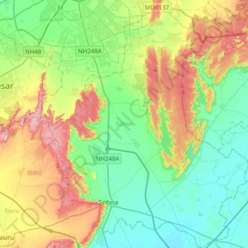
Name: Sohna topographic map, elevation, terrain.
Location: Sohna, Gurugram, Haryana, India (28.20057 77.00314 28.44658 77.22527)
Average elevation: 794 ft
Minimum elevation: 627 ft
Maximum elevation: 1,122 ft
Other topographic maps
Click on a map to view its topography, its elevation and its terrain.
Sector 62
India > Haryana > Gurugram District
Sector 62, Gurgaon, Gurugram District, Haryana, India
Average elevation: 771 ft
Sector 85
India > Haryana > Gurugram District
Sector 85, Manesar, Gurugram District, Haryana, India
Average elevation: 748 ft
Sector 109
India > Haryana > Gurugram District
Sector 109, Gurgaon, Gurugram District, Haryana, India
Average elevation: 702 ft
Gurgaon
India > Haryana > Gurugram District
Gurgaon, Gurugram District, Haryana, India
Average elevation: 778 ft
Leisure Valley Park
India > Haryana > Gurugram District
Leisure Valley Park, Sector 29, Gurgaon, Gurugram District, Haryana, India
Average elevation: 771 ft