Geolocate

Bennington topographic map

Click on the map to display elevation.

About this map

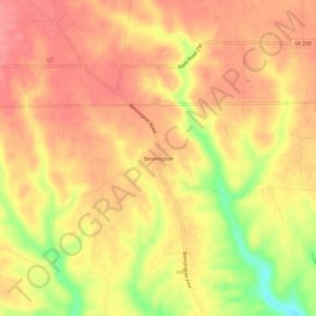
Name: Bennington topographic map, elevation, terrain.

Location: Bennington, Switzerland County, Indiana, United States (38.83895 -85.16051 38.87895 -85.12051)

Average elevation: 863 ft

Minimum elevation: 669 ft

Maximum elevation: 955 ft

Switzerland County trails, hiking, mountain biking, running and outdoor activities

Other topographic maps

Click on a map to view its topography, its elevation and its terrain.

Vevay

United States > Indiana > Switzerland County

Average elevation: 538 ft

Gear up for your next adventure:

🥤Water Filter Bottle - All‑in‑one filter bottle for safe hydration
🖼️Topo Map Wall Art - Decorative topographic prints of famous peaks and regions
🎒Trekking Poles - Sturdy poles for balance and stability on rough terrain
🛡️Bear Spray Outdoor - Protection in bear country hikes
🧷Carabiner Set - Durable clips for gear attachment

As an Amazon Associate, this site earns from qualifying purchases at no extra cost to you.