Geolocate

Aspley topographic map

Click on the map to display elevation.

About this map

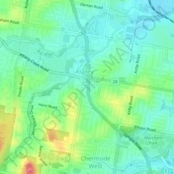
Name: Aspley topographic map, elevation, terrain.

Location: Aspley, City of Brisbane, Queensland, Australia (-27.37905 153.00107 -27.35233 153.03662)

Average elevation: 115 ft

Minimum elevation: 39 ft

Maximum elevation: 292 ft

Other topographic maps

Click on a map to view its topography, its elevation and its terrain.

Bulimba Creek

Australia > Queensland > City of Brisbane

Average elevation: 36 ft

Tangalooma

Australia > Queensland > City of Brisbane

Average elevation: 135 ft

Enoggera Hill

Australia > Queensland > City of Brisbane

Average elevation: 374 ft

Toohey Mountain

Australia > Queensland > City of Brisbane

Average elevation: 174 ft

Enoggera Dam

Australia > Queensland > City of Brisbane

Average elevation: 295 ft

Wilcannia Park

Australia > Queensland > City of Brisbane

Average elevation: 249 ft

Blunder Creek

Australia > Queensland > City of Brisbane

Average elevation: 85 ft

Tangalooma

Australia > Queensland > City of Brisbane

Average elevation: 135 ft

Timberland Park

Australia > Queensland > City of Brisbane

Average elevation: 121 ft

Deepwater Bend

Australia > Queensland > City of Brisbane

Average elevation: 16 ft

Gear up for your next adventure:

📡Handheld GPS Device - Reliable handheld GPS for outdoor navigation
🏕️Family Camping Gear - Essentials for group camping trips
🧯Portable Fire Pit - Compact fire pit for camping spots
🔪Outdoor Multitools - Essential survival tools for gear repair and field use
🧭GPS Watch Accessories - Bands and chargers for GPS watches

As an Amazon Associate, this site earns from qualifying purchases at no extra cost to you.