
Niari topographic map
Interactive map
Click on the map to display elevation.
About this map
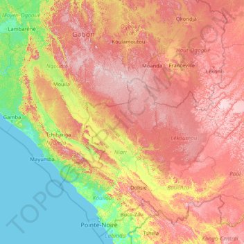
Name: Niari topographic map, elevation, terrain.
Location: Niari, Republic of the Congo (-5.30163 9.77321 -0.18163 14.89321)
Average elevation: 1,050 ft
Minimum elevation: 0 ft
Maximum elevation: 3,173 ft
Other topographic maps
Click on a map to view its topography, its elevation and its terrain.
Dolisie
Republic of the Congo > Niari > Dolisie
Dolisie, Niari, Republic of the Congo
Average elevation: 1,266 ft