Geolocate

Franklinville topographic map

Click on the map to display elevation.

About this map

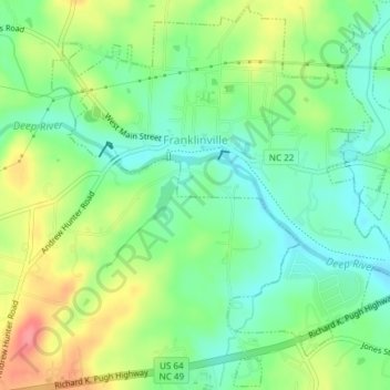
Name: Franklinville topographic map, elevation, terrain.

Location: Franklinville, Randolph County, North Carolina, United States (35.72498 -79.70806 35.75475 -79.67056)

Average elevation: 535 ft

Minimum elevation: 436 ft

Maximum elevation: 692 ft

Randolph County trails, hiking, mountain biking, running and outdoor activities

Other topographic maps

Click on a map to view its topography, its elevation and its terrain.

Farmer

United States > North Carolina > Randolph County

Average elevation: 482 ft

Glenola

United States > North Carolina > Randolph County

Average elevation: 764 ft

Westridge

United States > North Carolina > Randolph County

Average elevation: 732 ft

Pisgah

United States > North Carolina > Randolph County

Average elevation: 745 ft

Gear up for your next adventure:

🧭Outdoor Navigation Book - Learn advanced navigation skills
🔦LED Headlamp - Bright and durable LED headlamp for night navigation
🪶Trail Camera - Capture wildlife on your hikes
🧭Pro Hiking Compasses - High-accuracy liquid-filled compasses for topographic orientation
🧦Merino Wool Socks - Moisture-wicking, blister-preventing socks for long treks

As an Amazon Associate, this site earns from qualifying purchases at no extra cost to you.