Geolocate

Wrightstown topographic map

Click on the map to display elevation.

About this map

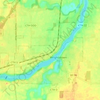
Name: Wrightstown topographic map, elevation, terrain.

Location: Wrightstown, Brown County, Wisconsin, 54180, United States (44.30976 -88.21341 44.34951 -88.14605)

Average elevation: 653 ft

Minimum elevation: 594 ft

Maximum elevation: 702 ft

Brown County trails, hiking, mountain biking, running and outdoor activities

Other topographic maps

Click on a map to view its topography, its elevation and its terrain.

Greenleaf

United States > Wisconsin > Brown County

Average elevation: 741 ft

Anston

United States > Wisconsin > Brown County

Average elevation: 738 ft

Champion

United States > Wisconsin > Brown County

Average elevation: 771 ft

New Franken

United States > Wisconsin > Brown County

Average elevation: 801 ft

Bellevue

United States > Wisconsin > Brown County > Bellevue > Bellevue

Average elevation: 692 ft

Holland

United States > Wisconsin > Brown County

Average elevation: 771 ft

Gear up for your next adventure:

🪶Fire Starter Kit - Reliable fire starter for survival and camping
🪶Camp Gear Gift Set - Perfect gift bundle for outdoor fans
🧢Sun Protection Hats - Wide-brimmed and UPF-rated hats for high-altitude sun safety
🥄Camping Utensil Set - Lightweight utensils for outdoor meals
🔦Compact Flashlight - Reliable flashlight for emergencies

As an Amazon Associate, this site earns from qualifying purchases at no extra cost to you.