Geolocate

Anston topographic map

Click on the map to display elevation.

About this map

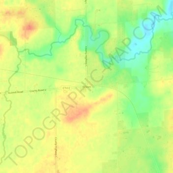
Name: Anston topographic map, elevation, terrain.

Location: Anston, Town of Pittsfield, Brown County, Wisconsin, United States (44.59721 -88.18038 44.63721 -88.14038)

Average elevation: 738 ft

Minimum elevation: 656 ft

Maximum elevation: 794 ft

Brown County trails, hiking, mountain biking, running and outdoor activities

Other topographic maps

Click on a map to view its topography, its elevation and its terrain.

Suamico

United States > Wisconsin > Brown County

Average elevation: 614 ft

Wrightstown

United States > Wisconsin > Brown County

Average elevation: 653 ft

Allouez

United States > Wisconsin > Brown County

Average elevation: 607 ft

Denmark

United States > Wisconsin > Brown County

Average elevation: 860 ft

Bellevue

United States > Wisconsin > Brown County

Average elevation: 705 ft

Gear up for your next adventure:

🏕️Family Camping Gear - Essentials for group camping trips
🪓Survival Multi‑Tool - Versatile tool for camp and trail tasks
🧦Hiking Socks - Comfortable socks to prevent blisters on long hikes
🔥Camping Stove - Portable stove for camping and backcountry cooking
🪑Ultralight Camp Chairs - Portable seating for resting after a long day of mapping

As an Amazon Associate, this site earns from qualifying purchases at no extra cost to you.