
Headington Hill topographic map
Interactive map
Click on the map to display elevation.
About this map
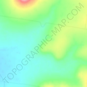
Name: Headington Hill topographic map, elevation, terrain.
Location: Headington Hill, Warwick, Queensland, 4370, Australia (-27.92528 152.02000 -27.90528 152.04000)
Average elevation: 1,719 ft
Minimum elevation: 1,604 ft
Maximum elevation: 1,969 ft
Other topographic maps
Click on a map to view its topography, its elevation and its terrain.
Mount Gay
Australia > Queensland > Warwick
Mount Gay, Warwick, Queensland, 4370, Australia
Average elevation: 2,421 ft
Warwick
Australia > Queensland > Warwick
Warwick, Queensland, 4370, Australia
Average elevation: 1,696 ft