Geolocate

Vinalmont topographic map

Interactive map

Click on the map to display elevation.

About this map

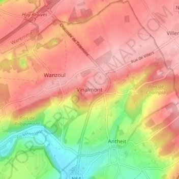
Name: Vinalmont topographic map, elevation, terrain.

Location: Vinalmont, Wanze, Huy, Liège, Wallonie, 4520, Belgique (50.54275 5.20614 50.58275 5.24614)

Average elevation: 512 ft

Minimum elevation: 236 ft

Maximum elevation: 673 ft

Other topographic maps

Click on a map to view its topography, its elevation and its terrain.

Oha

Belgique > Liège > Huy > Wanze > Bas-Oha

Oha, Bas-Oha, Wanze, Huy, Liège, Wallonie, 4520, Belgique

Average elevation: 384 ft

Champia

Belgique > Liège > Huy > Wanze

Champia, Wanze, Huy, Liège, Wallonie, 4520, Belgique

Average elevation: 489 ft

Le Taillis

Belgique > Liège > Huy > Wanze > Moha

Le Taillis, Moha, Wanze, Huy, Liège, Wallonie, 4520, Belgique

Average elevation: 453 ft

Le Tilleul

Belgique > Liège > Huy > Wanze > Le Tilleul

Le Tilleul, Wanze, Huy, Liège, Wallonie, 4520, Belgique

Average elevation: 390 ft

Wanzoul

Belgique > Liège > Huy > Wanze

Wanzoul, Wanze, Huy, Liège, Wallonie, 4520, Belgique

Average elevation: 505 ft

Antheit

Belgique > Liège > Huy > Wanze

Antheit, Wanze, Huy, Liège, Wallonie, 4520, Belgique

Average elevation: 449 ft