Geolocate

Mabini topographic map

Click on the map to display elevation.

About this map

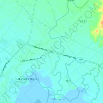
Name: Mabini topographic map, elevation, terrain.

Location: Mabini, San Jose, Occidental Mindoro, Mimaropa, Philippines (12.34971 121.07518 12.38971 121.11518)

Average elevation: 26 ft

Minimum elevation: -10 ft

Maximum elevation: 135 ft

Other topographic maps

Click on a map to view its topography, its elevation and its terrain.

Labangan

Philippines > Occidental Mindoro > San Jose > Mabini

Average elevation: 13 ft

Barangay 4

Philippines > Occidental Mindoro > San Jose

Average elevation: 10 ft

Bagong Sikat

Philippines > Occidental Mindoro > San Jose

Average elevation: 20 ft

Barangay 5

Philippines > Occidental Mindoro > San Jose

Average elevation: 10 ft

Bagong Sikat

Philippines > Occidental Mindoro > San Jose

Average elevation: 20 ft

Gear up for your next adventure:

📦Dry Bags Set - Waterproof storage for electronics and clothes
🔋Solar Power Banks - Keep your GPS and phone charged in remote wilderness areas
📦Gear Storage Bags - Organize and protect outdoor equipment
🎒Hydration Pack - Hands‑free water reservoir for long hikes
🌡️Portable Weather Meter - Track weather conditions on the trail

As an Amazon Associate, this site earns from qualifying purchases at no extra cost to you.