
Make a donation
Gear up for your next adventure:
As an Amazon Associate, this site earns from qualifying purchases at no extra cost to you.
Las Cuevas topographic map
Click on the map to display elevation.
Make a donation
Gear up for your next adventure:
As an Amazon Associate, this site earns from qualifying purchases at no extra cost to you.
About this map
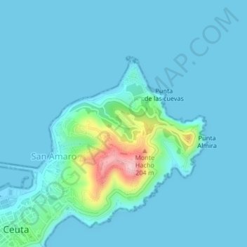
Name: Las Cuevas topographic map, elevation, terrain.
Average elevation: 69 ft
Minimum elevation: -3 ft
Maximum elevation: 630 ft
Make a donation
Gear up for your next adventure:
As an Amazon Associate, this site earns from qualifying purchases at no extra cost to you.
Other topographic maps
Click on a map to view its topography, its elevation and its terrain.
Ceuta
La morfología del terreno ceutí se debe al plegamiento alpino, que fraccionó esta tierra hasta la gran plataforma del Sáhara. Su principal accidente orográfico es el monte Hacho, formado por un anticlinal. El resto lo constituye un istmo que une el Hacho con el continente africano y un islote conocido…
Average elevation: 249 ft