Geolocate

Bracebridge topographic map

Click on the map to display elevation.

About this map

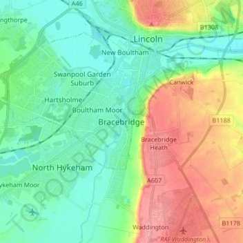
Name: Bracebridge topographic map, elevation, terrain.

Location: Bracebridge, Lincoln, Lincolnshire, Greater Lincolnshire, England, LN6 8RJ, United Kingdom (53.16205 -0.59523 53.24205 -0.51523)

Average elevation: 92 ft

Minimum elevation: -3 ft

Maximum elevation: 266 ft

Other topographic maps

Click on a map to view its topography, its elevation and its terrain.

Lincoln Castle

United Kingdom > England > Lincolnshire > Lincoln

Average elevation: 105 ft

Whittons Park

United Kingdom > England > Lincolnshire > Lincoln

Average elevation: 108 ft

Gear up for your next adventure:

🔦LED Headlamp - Bright and durable LED headlamp for night navigation
💧Water Filtration Bottles - Safely drink from streams and lakes while exploring
👟Trail Running Shoes - Lightweight shoes for trail runners
🥇GPS Hiking Watch - Multi‑sport GPS watch with navigation and trail tracking
🪓Survival Multi‑Tool - Versatile tool for camp and trail tasks

As an Amazon Associate, this site earns from qualifying purchases at no extra cost to you.