Geolocate

Moyock topographic map

Click on the map to display elevation.

About this map

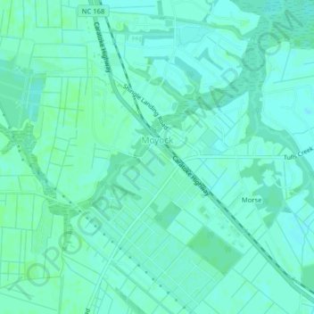
Name: Moyock topographic map, elevation, terrain.

Location: Moyock, Currituck County, North Carolina, United States (36.50690 -76.19037 36.53878 -76.15680)

Average elevation: 10 ft

Minimum elevation: 0 ft

Maximum elevation: 23 ft

Currituck County trails, hiking, mountain biking, running and outdoor activities

Other topographic maps

Click on a map to view its topography, its elevation and its terrain.

Barco

United States > North Carolina > Currituck County

Average elevation: 3 ft

Moyock

United States > North Carolina > Currituck County

Average elevation: 10 ft

Gear up for your next adventure:

🦶Carbon Trekking Poles - Reduce knee impact on steep descents with ultra-light poles
🔌USB Car Charger - Car charger for on‑the‑go power needs
🔥Fast-Boil Camping Stoves - Efficient cooking systems for quick trail meals
🪶Camp Gear Gift Set - Perfect gift bundle for outdoor fans
🗃️Trail First Aid Kit - Essential kit for outdoor injuries and emergencies

As an Amazon Associate, this site earns from qualifying purchases at no extra cost to you.