
Isla Fernandina topographic map
Click on the map to display elevation.
About this map
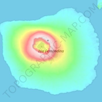
Name: Isla Fernandina topographic map, elevation, terrain.
Location: Isla Fernandina, Cantón Isabela, Galápagos, Ecuador (-0.50703 -91.66144 -0.26025 -91.37671)
Average elevation: 659 ft
Minimum elevation: 0 ft
Maximum elevation: 4,849 ft
Other topographic maps
Click on a map to view its topography, its elevation and its terrain.
Wolf
Ecuador > Galápagos > Cantón Isabela
Wolf Island (Spanish: Isla Wolf) is a small island in the northern Galápagos Islands. It has an area of 1.3 km2 (0.5 sq mi) and a maximum altitude of 253 m (830 ft) above sea level. The island is remote from the main archipelago and has no permanent population. The Galápagos National Park does not allow…
Average elevation: 49 ft
Roca Redonda
Ecuador > Galápagos > Cantón Isabela
Redonda Rock (Spanish: Roca Redonda, "Round Rock") is a flat-topped, steep-sided islet located roughly 25 km (16 mi) northwest of the island of Isabela in Ecuador's Galápagos Islands. Redonda measures 100 m (330 ft) long and 50 m (160 ft) wide with a maximum elevation of 67 m (220 ft). Its isolation and…
Average elevation: 0 ft