
Make a donation
Gear up for your next adventure:
As an Amazon Associate, this site earns from qualifying purchases at no extra cost to you.
Aire topographic map
Click on the map to display elevation.
Make a donation
Gear up for your next adventure:
As an Amazon Associate, this site earns from qualifying purchases at no extra cost to you.
About this map
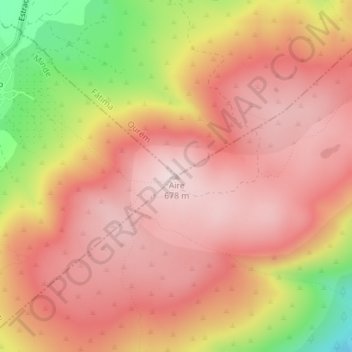
Name: Aire topographic map, elevation, terrain.
Location: Aire, Torres Novas, Santarém, 2395-027, Portugal (39.53575 -8.63670 39.53585 -8.63660)
Average elevation: 1,814 ft
Minimum elevation: 978 ft
Maximum elevation: 2,228 ft
Make a donation
Gear up for your next adventure:
As an Amazon Associate, this site earns from qualifying purchases at no extra cost to you.
Other topographic maps
Click on a map to view its topography, its elevation and its terrain.
Monumento Natural das Pegadas de Dinossáurios de Ourém/Torres Novas
Portugal > Santarém > Torres Novas > Chancelaria
Average elevation: 948 ft
Make a donation
Gear up for your next adventure:
As an Amazon Associate, this site earns from qualifying purchases at no extra cost to you.
Brogueira, Parceiros de Igreja e Alcorochel
Portugal > Santarém > Torres Novas
Average elevation: 256 ft
Make a donation
Gear up for your next adventure:
As an Amazon Associate, this site earns from qualifying purchases at no extra cost to you.