Geolocate

Perissa topographic map

Click on the map to display elevation.

About this map

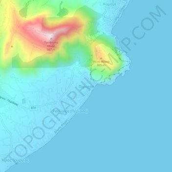
Name: Perissa topographic map, elevation, terrain.

Location: Perissa, Thira Municipal Unit, Municipality of Thira, Thira Regional Unit, South Aegean, Aegean, 847 03, Greece (36.33693 25.45387 36.37693 25.49387)

Average elevation: 249 ft

Minimum elevation: -10 ft

Maximum elevation: 1,831 ft

Other topographic maps

Click on a map to view its topography, its elevation and its terrain.

Gear up for your next adventure:

🎒Waterproof Dry Bags - Keep your electronics and maps dry inside your pack
👓Polarized Sunglasses - Outdoor sunglasses for glare reduction
🪶LED Camping Lantern - Bright lantern for camp lighting
🧣Hiking Neck Gaiter - Multi‑use neck protection for outdoor weather
🏫Relief Map Kits - Hands-on tools for teaching landforms and elevation

As an Amazon Associate, this site earns from qualifying purchases at no extra cost to you.