
Make a donation
Gear up for your next adventure:
As an Amazon Associate, this site earns from qualifying purchases at no extra cost to you.
Cambridge topographic map
Click on the map to display elevation.
Make a donation
Gear up for your next adventure:
As an Amazon Associate, this site earns from qualifying purchases at no extra cost to you.
About this map
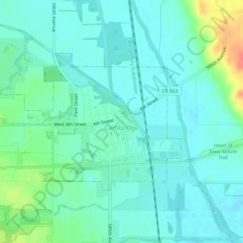
Name: Cambridge topographic map, elevation, terrain.
Location: Cambridge, Story County, Iowa, United States (41.89108 -93.56064 41.90849 -93.51925)
Average elevation: 876 ft
Minimum elevation: 837 ft
Maximum elevation: 1,001 ft
Story County trails, hiking, mountain biking, running and outdoor activities
Make a donation
Gear up for your next adventure:
As an Amazon Associate, this site earns from qualifying purchases at no extra cost to you.
Other topographic maps
Click on a map to view its topography, its elevation and its terrain.
Evergreen Lane (Briggs Terrace) Historical Site
United States > Iowa > Story County > Nevada
Average elevation: 997 ft
Make a donation
Gear up for your next adventure:
As an Amazon Associate, this site earns from qualifying purchases at no extra cost to you.