
Make a donation
Gear up for your next adventure:
As an Amazon Associate, this site earns from qualifying purchases at no extra cost to you.
Mansfield topographic map
Click on the map to display elevation.
Make a donation
Gear up for your next adventure:
As an Amazon Associate, this site earns from qualifying purchases at no extra cost to you.
Mansfield
Mansfield is located at 40°45′17″N 82°31′22″W / 40.75472°N 82.52278°W / 40.75472; -82.52278 (40.754856, −82.522855), directly between Columbus and Cleveland, however, the city lies in the western foothills of the Allegheny Plateau, and its elevation is among the highest of Ohio cities. The highest point in the city 1,493 feet (455 m) above sea level is located at the Woodland Reservoir, an underground water storage (service reservoir) along Woodland Road in southwest Mansfield. The elevation in downtown Mansfield, which is located at Central Park is 1,240 feet (378 m) above sea level, and at Mansfield Lahm Airport, the elevation is 1,293 feet (394 m) above sea level. The highest point in Richland County, second highest point in Ohio (after Campbell Hill) is between 1,510 feet (460 m) and 1,520 feet (463 m) above sea level is located southwest of the city, just off Lexington-Ontario Road at Apple Hill Orchards in Springfield Township.
Make a donation
Gear up for your next adventure:
As an Amazon Associate, this site earns from qualifying purchases at no extra cost to you.
About this map
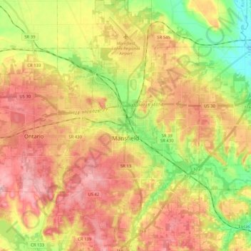
Name: Mansfield topographic map, elevation, terrain.
Location: Mansfield, Richland County, Ohio, United States (40.68864 -82.59004 40.84363 -82.45548)
Average elevation: 1,270 ft
Minimum elevation: 991 ft
Maximum elevation: 1,512 ft
Richland County trails, hiking, mountain biking, running and outdoor activities
Make a donation
Gear up for your next adventure:
As an Amazon Associate, this site earns from qualifying purchases at no extra cost to you.
Other topographic maps
Click on a map to view its topography, its elevation and its terrain.
Make a donation
Gear up for your next adventure:
As an Amazon Associate, this site earns from qualifying purchases at no extra cost to you.