
Make a donation
Gear up for your next adventure:
As an Amazon Associate, this site earns from qualifying purchases at no extra cost to you.
Presberg topographic map
Click on the map to display elevation.
Make a donation
Gear up for your next adventure:
As an Amazon Associate, this site earns from qualifying purchases at no extra cost to you.
Presberg
Presberg liegt im westlichen Hintertaunus, südlich der Wisper, hoch über deren Seitentälern auf einem Bergrücken in einer Höhe von etwa 360 bis 420 m ü. NN im Naturpark Rhein-Taunus. Während der Bergrücken rings um Presberg Rodungsgebiet ist, ist die weitere Umgebung als Teil des Wispertaunus ein reines Waldgebiet. Dieses Waldgebiet erstreckt sich vom Rhein über den Hinterlandswald bis weit in den Hohen Taunus.
Make a donation
Gear up for your next adventure:
As an Amazon Associate, this site earns from qualifying purchases at no extra cost to you.
About this map
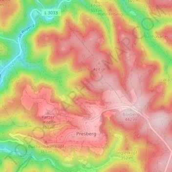
Name: Presberg topographic map, elevation, terrain.
Average elevation: 1,037 ft
Minimum elevation: 384 ft
Maximum elevation: 1,470 ft
Make a donation
Gear up for your next adventure:
As an Amazon Associate, this site earns from qualifying purchases at no extra cost to you.
Other topographic maps
Click on a map to view its topography, its elevation and its terrain.
Teufelskadrich
Deutschland > Hessen > Rheingau-Taunus-Kreis > Rüdesheim am Rhein > Aulhausen
Average elevation: 935 ft