Geolocate

Viterbo topographic map

Click on the map to display elevation.

About this map

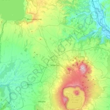
Name: Viterbo topographic map, elevation, terrain.

Location: Viterbo, Lazio, Italy (42.29815 11.90455 42.58823 12.22484)

Average elevation: 1,083 ft

Minimum elevation: 177 ft

Maximum elevation: 3,494 ft

Other topographic maps

Click on a map to view its topography, its elevation and its terrain.

Isola Bisentina

Italy > Lazio > Viterbo > Capodimonte

Average elevation: 997 ft

Monte Raschio

Italy > Lazio > Viterbo > Oriolo Romano

Average elevation: 1,470 ft

Bagnaia

Italy > Lazio > Viterbo > Viterbo

Average elevation: 1,522 ft

Cura

Italy > Lazio > Viterbo > Vetralla

Average elevation: 1,289 ft

Gear up for your next adventure:

🧭Map Reading Tools - Tools and kits for map navigation
🚑Emergency Bivvies - Heat-reflective sleeping bags for survival situations
🎒Trail Energy Bars - High‑calorie bars for hiking energy
🧥Waterproof Jacket for Hiking - Breathable and rugged rain jacket for outdoor excursions
🧼Biodegradable Camping Soap - Eco‑friendly soap for outdoor hygiene

As an Amazon Associate, this site earns from qualifying purchases at no extra cost to you.