
Make a donation
Gear up for your next adventure:
As an Amazon Associate, this site earns from qualifying purchases at no extra cost to you.
Roura topographic map
Click on the map to display elevation.
Make a donation
Gear up for your next adventure:
As an Amazon Associate, this site earns from qualifying purchases at no extra cost to you.
About this map
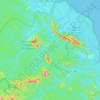
Name: Roura topographic map, elevation, terrain.
Location: Roura, Cayenne, French Guiana, France (4.09529 -52.85748 4.85674 -52.16282)
Average elevation: 157 ft
Minimum elevation: -10 ft
Maximum elevation: 1,535 ft
Make a donation
Gear up for your next adventure:
As an Amazon Associate, this site earns from qualifying purchases at no extra cost to you.
Other topographic maps
Click on a map to view its topography, its elevation and its terrain.
Make a donation
Gear up for your next adventure:
As an Amazon Associate, this site earns from qualifying purchases at no extra cost to you.
Make a donation
Gear up for your next adventure:
As an Amazon Associate, this site earns from qualifying purchases at no extra cost to you.
Saint-Laurent-du-Maroni
France > French Guiana > Saint-Laurent-du-Maroni > Saint-Laurent-du-Maroni
Average elevation: 30 ft