Geolocate

Colehill topographic map

Click on the map to display elevation.

About this map

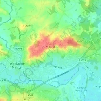
Name: Colehill topographic map, elevation, terrain.

Location: Colehill, Furzehill, Dorset, England, United Kingdom (50.79051 -2.00297 50.82248 -1.92772)

Average elevation: 98 ft

Minimum elevation: 33 ft

Maximum elevation: 249 ft

Gear up for your next adventure:

💧Water Filtration Bottles - Safely drink from streams and lakes while exploring
🪶Thermal Camp Blanket - Extra warmth for cold nights
🛠️Outdoor Gear Repair Kit - Essential tools to fix gear on the trail
🏥Hiking First Aid Kits - Comprehensive medical kits for remote trail injuries
🪶Compact Camp Shovel - Folding shovel for campsite tasks

As an Amazon Associate, this site earns from qualifying purchases at no extra cost to you.