
南坤镇 topographic map
Interactive map
Click on the map to display elevation.
About this map
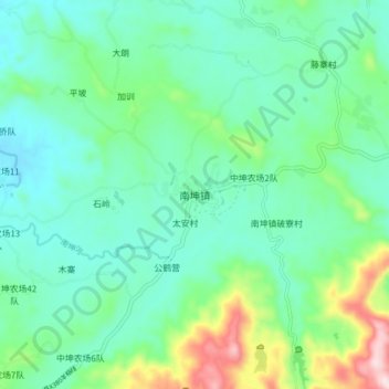
Name: 南坤镇 topographic map, elevation, terrain.
Location: 南坤镇, 屯昌县, 海南省, 571632, 中国 (19.27873 109.90608 19.35873 109.98608)
Average elevation: 627 ft
Minimum elevation: 325 ft
Maximum elevation: 1,591 ft
Other topographic maps
Click on a map to view its topography, its elevation and its terrain.