Geolocate

Backus topographic map

Click on the map to display elevation.

About this map

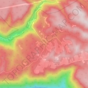
Name: Backus topographic map, elevation, terrain.

Location: Backus, Fayette County, West Virginia, United States (37.83443 -80.99455 37.87443 -80.95455)

Average elevation: 2,454 ft

Minimum elevation: 1,342 ft

Maximum elevation: 2,877 ft

Fayette County trails, hiking, mountain biking, running and outdoor activities

Other topographic maps

Click on a map to view its topography, its elevation and its terrain.

Ansted

United States > West Virginia > Fayette County

Average elevation: 1,572 ft

Powellton

United States > West Virginia > Fayette County

Average elevation: 1,552 ft

Smithers

United States > West Virginia > Fayette County

Average elevation: 1,119 ft

Pax

United States > West Virginia > Fayette County

Average elevation: 1,821 ft

Montgomery

United States > West Virginia > Fayette County

Average elevation: 1,106 ft

Gear up for your next adventure:

🌎3D Topographic Globes - Raised relief globes for a tactile understanding of geography
🔋Solar Power Banks - Keep your GPS and phone charged in remote wilderness areas
🛌Ultralight Sleeping Bags - Compact down bags for cold nights in the wilderness
🛠️Backpacking Tool Kit - Essential toolkit for outdoor repairs
🎒Waterproof Dry Bags - Keep your electronics and maps dry inside your pack

As an Amazon Associate, this site earns from qualifying purchases at no extra cost to you.