
Ναυάγιο topographic map
Interactive map
Click on the map to display elevation.
About this map
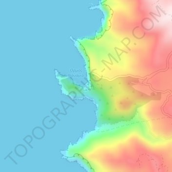
Name: Ναυάγιο topographic map, elevation, terrain.
Average elevation: 410 ft
Minimum elevation: -10 ft
Maximum elevation: 1,401 ft
Other topographic maps
Click on a map to view its topography, its elevation and its terrain.
Lithakia
Greece > Peloponnese, Western Greece and the Ionian > Zakynthos Regional Unit
Lithakia, Zakynthos Municipality, Zakynthos Regional Unit, Ioanian Islands, Peloponnese, Western Greece and the Ionian, 290 92, Greece
Average elevation: 502 ft
Vardiola in Tsilivi
Greece > Peloponnese, Western Greece and the Ionian > Zakynthos Regional Unit > Planos
Vardiola in Tsilivi, Τσιβιλή - Κάτω Γερακάρι, κ. Τραγακίου, Planos, Zakynthos Municipality, Zakynthos Regional Unit, Ioanian Islands, Peloponnese, Western Greece and the Ionian, 291 00, Greece
Average elevation: 39 ft
Zakynthos
Greece > Peloponnese, Western Greece and the Ionian > Zakynthos Regional Unit
Zakynthos, Zakynthos Regional Unit, Ioanian Islands, Peloponnese, Western Greece and the Ionian, Greece
Average elevation: 269 ft
Kalamaki
Greece > Peloponnese, Western Greece and the Ionian > Zakynthos Regional Unit
Kalamaki, Zakynthos Municipality, Zakynthos Regional Unit, Ioanian Islands, Peloponnese, Western Greece and the Ionian, 291 00, Greece
Average elevation: 190 ft
Alykanas
Greece > Peloponnese, Western Greece and the Ionian > Zakynthos Regional Unit
Alykanas, Zakynthos Municipality, Zakynthos Regional Unit, Ioanian Islands, Peloponnese, Western Greece and the Ionian, 290 90, Greece
Average elevation: 52 ft
Laganas
Greece > Peloponnese, Western Greece and the Ionian > Zakynthos Regional Unit > Laganas
Laganas, Zakynthos Municipality, Zakynthos Regional Unit, Ioanian Islands, Peloponnese, Western Greece and the Ionian, 29092, Greece
Average elevation: 26 ft