Make a donation
Gear up for your next adventure:
As an Amazon Associate, this site earns from qualifying purchases at no extra cost to you.
Kalamaki topographic map
Click on the map to display elevation.
Make a donation
Gear up for your next adventure:
As an Amazon Associate, this site earns from qualifying purchases at no extra cost to you.
About this map
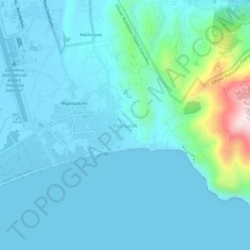
Name: Kalamaki topographic map, elevation, terrain.
Average elevation: 190 ft
Minimum elevation: -13 ft
Maximum elevation: 1,512 ft
Make a donation
Gear up for your next adventure:
As an Amazon Associate, this site earns from qualifying purchases at no extra cost to you.
Other topographic maps
Click on a map to view its topography, its elevation and its terrain.
Municipal Unit of Artemisia
Greece > Peloponnese, Western Greece and the Ionian > Zakynthos Regional Unit
Average elevation: 709 ft
Cameo island
Greece > Peloponnese, Western Greece and the Ionian > Zakynthos Regional Unit
Average elevation: 16 ft
Ναυάγιο
Greece > Peloponnese, Western Greece and the Ionian > Zakynthos Regional Unit
Average elevation: 410 ft
Stamfani
Greece > Peloponnese, Western Greece and the Ionian > Zakynthos Regional Unit
Average elevation: 3 ft
Make a donation
Gear up for your next adventure:
As an Amazon Associate, this site earns from qualifying purchases at no extra cost to you.
