Geolocate

Korgao topographic map

Click on the map to display elevation.

About this map

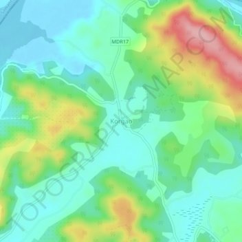
Name: Korgao topographic map, elevation, terrain.

Location: Korgao, Pernem, North Goa District, Goa, 416513, India (15.68977 73.73164 15.72977 73.77164)

Average elevation: 154 ft

Minimum elevation: -7 ft

Maximum elevation: 505 ft

Other topographic maps

Click on a map to view its topography, its elevation and its terrain.

Morjim Beach

India > Goa > Pernem

Average elevation: 10 ft

Arambol Sweet Water Lake

India > Goa > Pernem > Arambol

Average elevation: 82 ft

Gear up for your next adventure:

📶Vehicle Signal Boosters - Improve reception in rural areas while driving to trailheads
📶Satellite Messenger - Communication device off‑grid
⛑️Personal Locator Beacon - Safety beacon for emergencies
Backpacking Tents - Weight-optimized shelters for multi-day topographic surveys
📦Dry Bags Set - Waterproof storage for electronics and clothes

As an Amazon Associate, this site earns from qualifying purchases at no extra cost to you.