Geolocate

Canzano topographic map

Click on the map to display elevation.

👉 Easily get elevation data in JSON, GeoTIFF and KML formats using Elevation API
Thank you for supporting this site ❤️
Make a donation

About this map

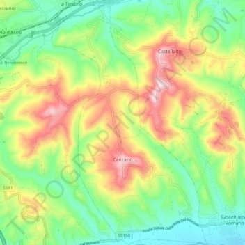
Name: Canzano topographic map, elevation, terrain.

Location: Canzano, Teramo, Abruzzo, Italy (42.62214 13.77527 42.69272 13.83690)

Average elevation: 807 ft

Minimum elevation: 289 ft

Maximum elevation: 1,575 ft

Other topographic maps

Click on a map to view its topography, its elevation and its terrain.

Favale

Italy > Abruzzo > Teramo > Civitella del Tronto

Average elevation: 607 ft

Intermesoli

Italy > Abruzzo > Teramo > Pietracamela

Average elevation: 2,913 ft

Marciano

Italy > Abruzzo > Teramo > Montefino

Average elevation: 850 ft

Villa Vomano

Italy > Abruzzo > Teramo > Teramo

Average elevation: 659 ft

Nerito

Italy > Abruzzo > Teramo

Average elevation: 3,081 ft

Villa Piano

Italy > Abruzzo > Teramo > Isola del Gran Sasso d'Italia

Average elevation: 1,913 ft

calanchi

Italy > Abruzzo > Teramo > Pineto > Mutignano

Average elevation: 515 ft

Gear up for your next adventure:

🪶Paracord Bracelet - Survival bracelet with built‑in tools
🔌Solar Panel Charger - Charge gear sustainably outdoors
🧷Carabiner Set - Durable clips for gear attachment
🥩Freeze-Dried Meals - Nutritious and lightweight food for remote expeditions
🎒Trekking Poles - Sturdy poles for balance and stability on rough terrain

As an Amazon Associate, this site earns from qualifying purchases at no extra cost to you.