
Make a donation
Gear up for your next adventure:
As an Amazon Associate, this site earns from qualifying purchases at no extra cost to you.
Wünnenberg topographic map
Click on the map to display elevation.
Make a donation
Gear up for your next adventure:
As an Amazon Associate, this site earns from qualifying purchases at no extra cost to you.
About this map
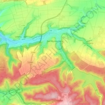
Name: Wünnenberg topographic map, elevation, terrain.
Average elevation: 1,158 ft
Minimum elevation: 820 ft
Maximum elevation: 1,516 ft
Make a donation
Gear up for your next adventure:
As an Amazon Associate, this site earns from qualifying purchases at no extra cost to you.
Other topographic maps
Click on a map to view its topography, its elevation and its terrain.
Aabachtalsperre
Deutschland > Nordrhein-Westfalen > Kreis Paderborn > Bad Wünnenberg
Die Aabachtalsperre liegt im Kreis Paderborn am Rand der Briloner Höhen zwischen Bad Wünnenberg im Nordwesten und Marsberg im Südosten. Das 27,2 km² große Einzugsgebiet der Talsperre erstreckt sich im Wesentlichen nach Südosten durch das Sintfeld und wird flankiert durch den „Fürstenberger Wald“ im…
Average elevation: 1,250 ft