
Make a donation
Gear up for your next adventure:
As an Amazon Associate, this site earns from qualifying purchases at no extra cost to you.
Le Pin-en-Mauges topographic map
Click on the map to display elevation.
Make a donation
Gear up for your next adventure:
As an Amazon Associate, this site earns from qualifying purchases at no extra cost to you.
Le Pin-en-Mauges
La superficie de la commune est de plus de 17 km2 (1 707 ha) et son altitude varie de 79 à 129 mètres.
Make a donation
Gear up for your next adventure:
As an Amazon Associate, this site earns from qualifying purchases at no extra cost to you.
About this map
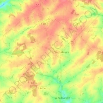
Name: Le Pin-en-Mauges topographic map, elevation, terrain.
Average elevation: 358 ft
Minimum elevation: 226 ft
Maximum elevation: 440 ft
Make a donation
Gear up for your next adventure:
As an Amazon Associate, this site earns from qualifying purchases at no extra cost to you.
Other topographic maps
Click on a map to view its topography, its elevation and its terrain.
La Poitevinière
France > Pays de la Loire > Maine-et-Loire > Beaupréau-en-Mauges
Average elevation: 318 ft
La Louettière
France > Pays de la Loire > Maine-et-Loire > Beaupréau-en-Mauges
Average elevation: 354 ft
La Vesselière
France > Pays de la Loire > Maine-et-Loire > Beaupréau-en-Mauges > Gesté
Average elevation: 269 ft
Make a donation
Gear up for your next adventure:
As an Amazon Associate, this site earns from qualifying purchases at no extra cost to you.
Jallais
France > Pays de la Loire > Maine-et-Loire > Beaupréau-en-Mauges
L'altitude de la commune varie de 57 à 121 mètres, et son territoire s'étend sur près de 53 km2 (5 287 hectares).
Average elevation: 299 ft
La Jubaudière
France > Pays de la Loire > Maine-et-Loire > Beaupréau-en-Mauges
Average elevation: 318 ft
La Roche Baraton
France > Pays de la Loire > Maine-et-Loire > Beaupréau-en-Mauges
Average elevation: 256 ft
Les Petites Places
France > Pays de la Loire > Maine-et-Loire > Beaupréau-en-Mauges
Average elevation: 279 ft
Make a donation
Gear up for your next adventure:
As an Amazon Associate, this site earns from qualifying purchases at no extra cost to you.
La Jambuère
France > Pays de la Loire > Maine-et-Loire > Beaupréau-en-Mauges
Average elevation: 351 ft
Les Cabournes
France > Pays de la Loire > Maine-et-Loire > Beaupréau-en-Mauges
Average elevation: 354 ft
Étang de la Thévinière
France > Pays de la Loire > Maine-et-Loire > Beaupréau-en-Mauges > Gesté > Le Grand Moulin
Average elevation: 308 ft
Make a donation
Gear up for your next adventure:
As an Amazon Associate, this site earns from qualifying purchases at no extra cost to you.
La Foucherie
France > Pays de la Loire > Maine-et-Loire > Beaupréau-en-Mauges
Average elevation: 285 ft
Bois de la Poironnière
France > Pays de la Loire > Maine-et-Loire > Beaupréau-en-Mauges
Average elevation: 367 ft
Le Val d'Evre
France > Pays de la Loire > Maine-et-Loire > Beaupréau-en-Mauges
Average elevation: 269 ft
La Raillère
France > Pays de la Loire > Maine-et-Loire > Beaupréau-en-Mauges
Average elevation: 295 ft
Make a donation
Gear up for your next adventure:
As an Amazon Associate, this site earns from qualifying purchases at no extra cost to you.
Merveille
France > Pays de la Loire > Maine-et-Loire > Beaupréau-en-Mauges > Merveille
Average elevation: 331 ft