
Make a donation
Gear up for your next adventure:
As an Amazon Associate, this site earns from qualifying purchases at no extra cost to you.
Surat Thani topographic map
Click on the map to display elevation.
Make a donation
Gear up for your next adventure:
As an Amazon Associate, this site earns from qualifying purchases at no extra cost to you.
About this map
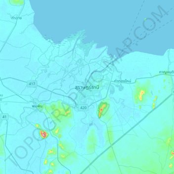
Name: Surat Thani topographic map, elevation, terrain.
Location: Surat Thani, Wat Pradu, Surat Thani Province, 84000, Thailand (8.98041 99.16413 9.30041 99.48413)
Average elevation: 33 ft
Minimum elevation: -3 ft
Maximum elevation: 938 ft
Make a donation
Gear up for your next adventure:
As an Amazon Associate, this site earns from qualifying purchases at no extra cost to you.
Other topographic maps
Click on a map to view its topography, its elevation and its terrain.
Ko Pha Ngan
Thailand > Surat Thani Province
Due to its topography, the population hugs the coastline. The mountainous interior is generally inaccessible. More than half the island designated as national park and Ko Pha-ngan has more than 80 km2 (31 sq mi) of relatively unspoiled rain forest with diverse flora and fauna. It is also considered a spiritual…
Average elevation: 276 ft