
Make a donation
Gear up for your next adventure:
As an Amazon Associate, this site earns from qualifying purchases at no extra cost to you.
Clinton topographic map
Click on the map to display elevation.
Make a donation
Gear up for your next adventure:
As an Amazon Associate, this site earns from qualifying purchases at no extra cost to you.
About this map
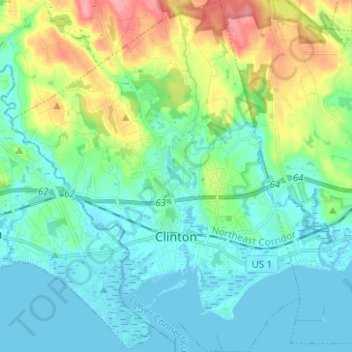
Name: Clinton topographic map, elevation, terrain.
Average elevation: 89 ft
Minimum elevation: -3 ft
Maximum elevation: 351 ft
Make a donation
Gear up for your next adventure:
As an Amazon Associate, this site earns from qualifying purchases at no extra cost to you.
Other topographic maps
Click on a map to view its topography, its elevation and its terrain.
Lake Pocotopaug
United States > Connecticut > Lower Connecticut River Valley Planning Region > East Hampton
Average elevation: 604 ft
Essex Village
United States > Connecticut > Lower Connecticut River Valley Planning Region > Essex
Average elevation: 72 ft
Pond Meadow
United States > Connecticut > Lower Connecticut River Valley Planning Region > Westbrook
Average elevation: 174 ft
Field Park
United States > Connecticut > Lower Connecticut River Valley Planning Region > Middletown > Newfield Heights
Average elevation: 128 ft
Make a donation
Gear up for your next adventure:
As an Amazon Associate, this site earns from qualifying purchases at no extra cost to you.
Goodspeeds Landing
United States > Connecticut > Lower Connecticut River Valley Planning Region > East Haddam
Average elevation: 171 ft
Oxford Park
United States > Connecticut > Lower Connecticut River Valley Planning Region > Cromwell
Average elevation: 105 ft
Chester Center
United States > Connecticut > Lower Connecticut River Valley Planning Region > Chester
Average elevation: 171 ft
Pameacha Pond
United States > Connecticut > Lower Connecticut River Valley Planning Region > Middletown
Average elevation: 135 ft
Make a donation
Gear up for your next adventure:
As an Amazon Associate, this site earns from qualifying purchases at no extra cost to you.
Dooley Pond
United States > Connecticut > Lower Connecticut River Valley Planning Region > Middletown
Average elevation: 318 ft