
Thank you for supporting this site ❤️
Make a donation
Make a donation
Gear up for your next adventure:
As an Amazon Associate, this site earns from qualifying purchases at no extra cost to you.
Maito topographic map
Click on the map to display elevation.
Thank you for supporting this site ❤️
Make a donation
Make a donation
Gear up for your next adventure:
As an Amazon Associate, this site earns from qualifying purchases at no extra cost to you.
About this map
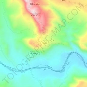
Name: Maito topographic map, elevation, terrain.
Location: Maito, Tarqui, Centro, Huila, RAP (Especial) Central, Colombia (2.02645 -75.92847 2.06645 -75.88847)
Average elevation: 3,366 ft
Minimum elevation: 2,779 ft
Maximum elevation: 4,616 ft
Thank you for supporting this site ❤️
Make a donation
Make a donation
Gear up for your next adventure:
As an Amazon Associate, this site earns from qualifying purchases at no extra cost to you.