
Lake Ripley topographic map
Click on the map to display elevation.
About this map
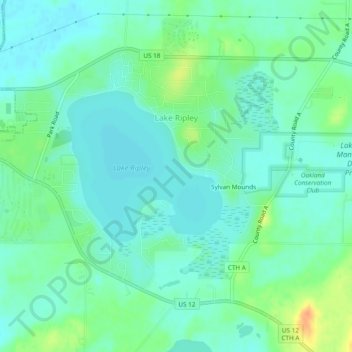
Name: Lake Ripley topographic map, elevation, terrain.
Location: Lake Ripley, Jefferson County, Wisconsin, United States (42.98753 -89.01263 43.01286 -88.96507)
Average elevation: 860 ft
Minimum elevation: 823 ft
Maximum elevation: 955 ft
Jefferson County trails, hiking, mountain biking, running and outdoor activities
Other topographic maps
Click on a map to view its topography, its elevation and its terrain.
Aztalan State Park
United States > Wisconsin > Jefferson County > Town of Aztalan
Average elevation: 837 ft